Artículos de revista
|
2020
|
Duque, Juan C; Lozano-Gracia, Nancy ; Patino, Jorge E; Restrepo, Paula Institutional fragmentation and metropolitan coordination in Latin American cities: Are there links with city productivity? Artículo de revista Regional Science Policy & Practice, pp. 1-33, 2020, ISSN: 1757-7802. Resumen | Enlaces | BibTeX | Etiquetas: Ciudades y su economía, imágenes satelitales, productividad @article{duque2020institutional,
title = {Institutional fragmentation and metropolitan coordination in Latin American cities: Are there links with city productivity?},
author = {Duque, Juan C. and Lozano-Gracia, Nancy and Patino, Jorge E. and Restrepo, Paula},
url = {https://doi.org/10.1111/rsp3.12314},
doi = {10.1111/rsp3.12314},
issn = {1757-7802},
year = {2020},
date = {2020-07-08},
journal = {Regional Science Policy & Practice},
pages = {1-33},
abstract = {This paper provides empirical evidence on the impact of institutional fragmentation and metropolitan coordination on urban productivity in Latin American Cities. The use of night‐time lights satellite imagery and high-resolution population data allow us to use a definition of metropolitan area based on the urban extents that result from the union between the formally defined metropolitan areas and the contiguous patches of urbanized areas with more than 500,000 inhabitants. Initial results suggest that the presence of multiple local governments within metropolitan areas generate opposite effects in urban productivity. On the one hand, smaller governments tend to be more responsive and efficient, which increases productivity. But, on the other hand, multiple local governments face co‐ordination costs that result in lower productivity levels.},
keywords = {Ciudades y su economía, imágenes satelitales, productividad},
pubstate = {published},
tppubtype = {article}
}
This paper provides empirical evidence on the impact of institutional fragmentation and metropolitan coordination on urban productivity in Latin American Cities. The use of night‐time lights satellite imagery and high-resolution population data allow us to use a definition of metropolitan area based on the urban extents that result from the union between the formally defined metropolitan areas and the contiguous patches of urbanized areas with more than 500,000 inhabitants. Initial results suggest that the presence of multiple local governments within metropolitan areas generate opposite effects in urban productivity. On the one hand, smaller governments tend to be more responsive and efficient, which increases productivity. But, on the other hand, multiple local governments face co‐ordination costs that result in lower productivity levels. |
Gómez, Jairo A; Patiño, Jorge E; Duque, Juan C; Passos, Santiago Spatiotemporal Modeling of Urban Growth Using Machine Learning Artículo de revista Remote Sensing, 12(1) (109), pp. 1-41, 2020, ISSN: 2072-4292. Resumen | Enlaces | BibTeX | Etiquetas: Aprendizaje de máquina, Crecimiento de ciudades, imágenes satelitales @article{gomez2020spatiotemporal,
title = {Spatiotemporal Modeling of Urban Growth Using Machine Learning},
author = {Gómez, Jairo A. and Patiño, Jorge E. and Duque, Juan C. and Passos, Santiago },
url = {https://doi.org/10.3390/rs12010109},
doi = {10.3390/rs12010109},
issn = {2072-4292},
year = {2020},
date = {2020-01-01},
journal = {Remote Sensing},
volume = {12(1)},
number = {109},
pages = {1-41},
abstract = {This paper presents a general framework for modeling the growth of three important variables for cities: population distribution, binary urban footprint, and urban footprint in color. The framework models the population distribution as a spatiotemporal regression problem using machine learning, and it obtains the binary urban footprint from the population distribution through a binary classifier plus a temporal correction for existing urban regions. The framework estimates the urban footprint in color from its previous value, as well as from past and current values of the binary urban footprint using a semantic inpainting algorithm. By combining this framework with free data from the Landsat archive and the Global Human Settlement Layer framework, interested users can get approximate growth predictions of any city in the world. These predictions can be improved with the inclusion in the framework of additional spatially distributed input variables over time subject to availability. Unlike widely used growth models based on cellular automata, there are two main advantages of using the proposed machine learning-based framework. Firstly, it does not require to define rules a priori because the model learns the dynamics of growth directly from the historical data. Secondly, it is very easy to train new machine learning models using different explanatory input variables to assess their impact. As a proof of concept, we tested the framework in Valledupar and Rionegro, two Latin American cities located in Colombia with different geomorphological characteristics, and found that the model predictions were in close agreement with the ground-truth based on performance metrics, such as the root-mean-square error, zero-mean normalized cross-correlation, Pearson’s correlation coefficient for continuous variables, and a few others for discrete variables such as the intersection over union, accuracy, and the f1 metric. In summary, our framework for modeling urban growth is flexible, allows sensitivity analyses, and can help policymakers worldwide to assess different what-if scenarios during the planning cycle of sustainable and resilient cities.},
keywords = {Aprendizaje de máquina, Crecimiento de ciudades, imágenes satelitales},
pubstate = {published},
tppubtype = {article}
}
This paper presents a general framework for modeling the growth of three important variables for cities: population distribution, binary urban footprint, and urban footprint in color. The framework models the population distribution as a spatiotemporal regression problem using machine learning, and it obtains the binary urban footprint from the population distribution through a binary classifier plus a temporal correction for existing urban regions. The framework estimates the urban footprint in color from its previous value, as well as from past and current values of the binary urban footprint using a semantic inpainting algorithm. By combining this framework with free data from the Landsat archive and the Global Human Settlement Layer framework, interested users can get approximate growth predictions of any city in the world. These predictions can be improved with the inclusion in the framework of additional spatially distributed input variables over time subject to availability. Unlike widely used growth models based on cellular automata, there are two main advantages of using the proposed machine learning-based framework. Firstly, it does not require to define rules a priori because the model learns the dynamics of growth directly from the historical data. Secondly, it is very easy to train new machine learning models using different explanatory input variables to assess their impact. As a proof of concept, we tested the framework in Valledupar and Rionegro, two Latin American cities located in Colombia with different geomorphological characteristics, and found that the model predictions were in close agreement with the ground-truth based on performance metrics, such as the root-mean-square error, zero-mean normalized cross-correlation, Pearson’s correlation coefficient for continuous variables, and a few others for discrete variables such as the intersection over union, accuracy, and the f1 metric. In summary, our framework for modeling urban growth is flexible, allows sensitivity analyses, and can help policymakers worldwide to assess different what-if scenarios during the planning cycle of sustainable and resilient cities. |
2019
|
Duque, Juan C; Lozano-Gracia, Nancy ; Patino, Jorge E; Restrepo, Paula ; Velasquez, Wilson A Spatiotemporal dynamics of urban growth in Latin American cities: An analysis using nighttime light imagery Artículo de revista Landscape and Urban Planning, 191 (103640), pp. 1-15, 2019, ISSN: 0169-2046. Resumen | Enlaces | BibTeX | Etiquetas: Crecimiento de ciudades, imágenes satelitales @article{duque2019spatiotemporal,
title = {Spatiotemporal dynamics of urban growth in Latin American cities: An analysis using nighttime light imagery},
author = {Duque, Juan C. and Lozano-Gracia, Nancy and Patino, Jorge E. and Restrepo, Paula and Velasquez, Wilson A.},
url = {https://doi.org/10.1016/j.landurbplan.2019.103640},
doi = {10.1016/j.landurbplan.2019.103640},
issn = {0169-2046},
year = {2019},
date = {2019-11-01},
journal = {Landscape and Urban Planning},
volume = {191},
number = {103640},
pages = {1-15},
abstract = {The impact of urban form on economic performance and quality of life has been widely recognized. Studies regarding urban form have focused on developed countries; only a small number of cities in developing countries have been studied. This paper utilizes nighttime light imagery and information regarding street networks, automatically retrieved from OpenStreetMap, to calculate a series of spatial metrics that capture different aspects of the urban form of 919 Latin American and Caribbean cities. We study the relationship between the urban form metrics and several factors that can correlate with urban form (topography, size, colony, and economic performance) and perform a spatiotemporal analysis of urban growth from 1996 to 2010. Among the results, we highlight the tendency of a group of cities to grow on steeper slopes and several worrying aspects, specifically urban growth in protected areas and a trend to sprawl-growing in certain Latin American and Caribbean cities.},
keywords = {Crecimiento de ciudades, imágenes satelitales},
pubstate = {published},
tppubtype = {article}
}
The impact of urban form on economic performance and quality of life has been widely recognized. Studies regarding urban form have focused on developed countries; only a small number of cities in developing countries have been studied. This paper utilizes nighttime light imagery and information regarding street networks, automatically retrieved from OpenStreetMap, to calculate a series of spatial metrics that capture different aspects of the urban form of 919 Latin American and Caribbean cities. We study the relationship between the urban form metrics and several factors that can correlate with urban form (topography, size, colony, and economic performance) and perform a spatiotemporal analysis of urban growth from 1996 to 2010. Among the results, we highlight the tendency of a group of cities to grow on steeper slopes and several worrying aspects, specifically urban growth in protected areas and a trend to sprawl-growing in certain Latin American and Caribbean cities. |
2017
|
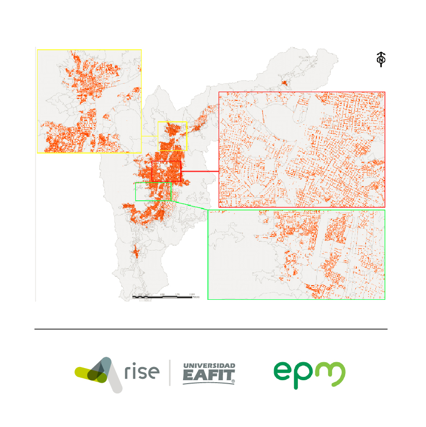
Duque, Juan C; Patino, Jorge E; Betancourt, Alejandro Exploring the potential of machine learning for automatic slum identification from VHR imagery Artículo de revista Remote Sensing, 9(9) (895), pp. 1-23, 2017, ISSN: 2072-4292. Resumen | Enlaces | BibTeX | Etiquetas: Aprendizaje de máquina, imágenes satelitales, pobreza, Sostenibilidad de ciudades @article{duque2017exploring,
title = {Exploring the potential of machine learning for automatic slum identification from VHR imagery},
author = {Duque, Juan C. and Patino, Jorge E. and Betancourt, Alejandro},
url = {https://doi.org/10.3390/rs9090895},
doi = {10.3390/rs9090895},
issn = {2072-4292},
year = {2017},
date = {2017-08-30},
journal = {Remote Sensing},
volume = {9(9)},
number = {895},
pages = {1-23},
abstract = {Slum identification in urban settlements is a crucial step in the process of formulation of pro-poor policies. However, the use of conventional methods for slum detection such as field surveys can be time-consuming and costly. This paper explores the possibility of implementing a low-cost standardized method for slum detection. We use spectral, texture and structural features extracted from very high spatial resolution imagery as input data and evaluate the capability of three machine learning algorithms (Logistic Regression, Support Vector Machine and Random Forest) to classify urban areas as slum or no-slum. Using data from Buenos Aires (Argentina), Medellin (Colombia) and Recife (Brazil), we found that Support Vector Machine with radial basis kernel delivers the best performance (with F2-scores over 0.81). We also found that singularities within cities preclude the use of a unified classification model.},
keywords = {Aprendizaje de máquina, imágenes satelitales, pobreza, Sostenibilidad de ciudades},
pubstate = {published},
tppubtype = {article}
}
Slum identification in urban settlements is a crucial step in the process of formulation of pro-poor policies. However, the use of conventional methods for slum detection such as field surveys can be time-consuming and costly. This paper explores the possibility of implementing a low-cost standardized method for slum detection. We use spectral, texture and structural features extracted from very high spatial resolution imagery as input data and evaluate the capability of three machine learning algorithms (Logistic Regression, Support Vector Machine and Random Forest) to classify urban areas as slum or no-slum. Using data from Buenos Aires (Argentina), Medellin (Colombia) and Recife (Brazil), we found that Support Vector Machine with radial basis kernel delivers the best performance (with F2-scores over 0.81). We also found that singularities within cities preclude the use of a unified classification model. |
|
|
2020
|
Gómez, Jairo A; Patiño, Jorge E; Duque, Juan C; Passos, Santiago Hacia un futuro más sostenible a través del modelado, planificación y control del crecimiento urbano basado en datos Informe técnico RiSE-group (1), 2020. Resumen | Enlaces | BibTeX | Etiquetas: briefings, Crecimiento de ciudades, imágenes satelitales @techreport{peak_briefing_1s,
title = {Hacia un futuro más sostenible a través del modelado, planificación y control del crecimiento urbano basado en datos},
author = {Gómez, Jairo A. and Patiño, Jorge E. and Duque, Juan C. and Passos, Santiago},
url = {https://www.rise-group.org/wp-content/uploads/2021/01/briefing_1.pdf
https://www.rise-group.org/wp-content/uploads/2021/03/briefing_1e.pdf},
year = {2020},
date = {2020-08-01},
number = {1},
institution = {RiSE-group},
abstract = {Este informe de investigación destaca el valor de utilizar un modelo de crecimiento urbano basado en datos para predecir el impacto de ciertas decisiones administrativas y políticas en la expansión o densificación a largo plazo de una ciudad. Cuando el modelo se usa como parte del ciclo de planificación urbana (ver Figura 1), sirve como un mecanismo para la toma de decisiones que apoya el crecimiento sostenible. Para otros actores urbanos interesados,como empresas de servicios públicos y constructoras, el modelo puede proporcionar información valiosa de planificación para la demanda futura de servicios e infraestructura.},
keywords = {briefings, Crecimiento de ciudades, imágenes satelitales},
pubstate = {published},
tppubtype = {techreport}
}
Este informe de investigación destaca el valor de utilizar un modelo de crecimiento urbano basado en datos para predecir el impacto de ciertas decisiones administrativas y políticas en la expansión o densificación a largo plazo de una ciudad. Cuando el modelo se usa como parte del ciclo de planificación urbana (ver Figura 1), sirve como un mecanismo para la toma de decisiones que apoya el crecimiento sostenible. Para otros actores urbanos interesados,como empresas de servicios públicos y constructoras, el modelo puede proporcionar información valiosa de planificación para la demanda futura de servicios e infraestructura. |