Artículos de revista
|
2021
|
Hong A., Martínez Patino Duque Rahimi L M J E J C K Neighbourhood green space and health disparities in the global South: Evidence from Cali, Colombia Artículo de revista Health and Place, 72 (102690), pp. 1-9, 2021, ISSN: 1353-8292. Resumen | Enlaces | BibTeX | Etiquetas: ODS 11, Sostenibilidad de ciudades @article{HongMartinezEtal2021,
title = {Neighbourhood green space and health disparities in the global South: Evidence from Cali, Colombia},
author = {Hong, A., Martínez L.M., Patino J.E., Duque J.C., Rahimi K.},
editor = {Elsevier},
doi = {10.1016/j.healthplace.2021.102690},
issn = {1353-8292},
year = {2021},
date = {2021-10-04},
journal = {Health and Place},
volume = {72},
number = {102690},
pages = {1-9},
abstract = {Increasing attention has been given to the role of green space in reducing health disparities. However, robust evidence to support decision making is lacking in the global South. We investigate the relationship between green space and health as well as its underlying mechanism in Cali, Colombia. Results indicate that neigh- bourhood greenness is associated with enhanced self-rated ‘good’ health and reduced physical and mental distress. The health benefits of green space appear to be stronger for people living in wealthier neighbourhoods than those in poor neighbourhoods. Results highlight the importance of considering health disparities for future green infrastructure planning in the global South context.},
keywords = {ODS 11, Sostenibilidad de ciudades},
pubstate = {published},
tppubtype = {article}
}
Increasing attention has been given to the role of green space in reducing health disparities. However, robust evidence to support decision making is lacking in the global South. We investigate the relationship between green space and health as well as its underlying mechanism in Cali, Colombia. Results indicate that neigh- bourhood greenness is associated with enhanced self-rated ‘good’ health and reduced physical and mental distress. The health benefits of green space appear to be stronger for people living in wealthier neighbourhoods than those in poor neighbourhoods. Results highlight the importance of considering health disparities for future green infrastructure planning in the global South context. |
Patiño, Jorge E; Hong, Andy ; Duque, Juan C; Rahimi, Kazem ; Zapata, Silvana ; Lopera, Verónica M Built environment and mortality risk from cardiovascular disease and diabetes in Medellín, Colombia: An ecological study. Artículo de revista Landscape and Urban Planning, 213 (104126), pp. 12, 2021, ISBN: 0169-2046. Resumen | Enlaces | BibTeX | Etiquetas: Sostenibilidad de ciudades @article{Patino2021,
title = {Built environment and mortality risk from cardiovascular disease and diabetes in Medellín, Colombia: An ecological study.},
author = {Patiño, Jorge E. and Hong, Andy and Duque, Juan C. and Rahimi, Kazem and Zapata, Silvana and Lopera, Verónica M.},
url = {https://doi.org/10.1016/j.landurbplan.2021.104126},
doi = {10.1016/j.landurbplan.2021.104126},
isbn = {0169-2046},
year = {2021},
date = {2021-05-01},
journal = {Landscape and Urban Planning},
volume = {213},
number = {104126},
pages = {12},
abstract = {• We analyze the built-environment and public health outcomes in Medellin (CO).
• Greenness showed the strongest negative association with the mortality measures.
• We found curvilinear relationships with some urban features.
• Intersection density relates negatively to the mortality rates after 200 int./km2.
• The densities of amenities and population show the opposite: U-shape relationships.},
keywords = {Sostenibilidad de ciudades},
pubstate = {published},
tppubtype = {article}
}
• We analyze the built-environment and public health outcomes in Medellin (CO).
• Greenness showed the strongest negative association with the mortality measures.
• We found curvilinear relationships with some urban features.
• Intersection density relates negatively to the mortality rates after 200 int./km2.
• The densities of amenities and population show the opposite: U-shape relationships. |
2020
|
Rueda-Plata, Diego ; Gonzales, Daniela ; Acevedo, Ana B; Duque, Juan C; Ramos-Pollán, Raúl. Use of deep learning models in street-level images to classify one-story unreinforced masonry buildings based on roof diaphragms Artículo de revista Building and Environment, 189 (107517), pp. 1-10, 2020, ISSN: 0360-1323. Resumen | Enlaces | BibTeX | Etiquetas: Redes neuronales, Sostenibilidad de ciudades @article{Rueda2020,
title = {Use of deep learning models in street-level images to classify one-story unreinforced masonry buildings based on roof diaphragms},
author = {Rueda-Plata, Diego and Gonzales, Daniela and Acevedo, Ana B. and Duque, Juan C. and Ramos-Pollán, Raúl.},
url = {https://doi.org/10.1016/j.buildenv.2020.107517},
doi = {10.1016/j.buildenv.2020.107517},
issn = {0360-1323},
year = {2020},
date = {2020-12-21},
journal = {Building and Environment},
volume = {189},
number = {107517},
pages = {1-10},
abstract = {In this paper, we explore the potential of convolutional neural networks to classify street-level imagery of one-story unreinforced masonry buildings (MURs) according to the flexibility of the roof diaphragm (rigid or flexible). This information is critical for vulnerability studies, disaster risk assessments, disaster management strategies, etc., and is of great relevance in cities where unreinforced masonry is the most common building typology or where the majority of the population resides in such buildings. Our contribution could be useful for local governments of cities in developing countries seeking to significantly reduce the number of deaths caused by disasters. Our research results indicate that VGG19 is the convolutional neural network architecture with the best performance, with an accuracy of 0.80, a precision of 0.88, and a recall of 0.84. The results are encouraging and could be used to reduce the amount of resources (both human and economic) for the development of detailed exposure models for unreinforced masonry buildings.},
keywords = {Redes neuronales, Sostenibilidad de ciudades},
pubstate = {published},
tppubtype = {article}
}
In this paper, we explore the potential of convolutional neural networks to classify street-level imagery of one-story unreinforced masonry buildings (MURs) according to the flexibility of the roof diaphragm (rigid or flexible). This information is critical for vulnerability studies, disaster risk assessments, disaster management strategies, etc., and is of great relevance in cities where unreinforced masonry is the most common building typology or where the majority of the population resides in such buildings. Our contribution could be useful for local governments of cities in developing countries seeking to significantly reduce the number of deaths caused by disasters. Our research results indicate that VGG19 is the convolutional neural network architecture with the best performance, with an accuracy of 0.80, a precision of 0.88, and a recall of 0.84. The results are encouraging and could be used to reduce the amount of resources (both human and economic) for the development of detailed exposure models for unreinforced masonry buildings. |
Gonzalez, Daniela ; Rueda-Plata, Diego ; Acevedo, Ana B; Duque, Juan C; Ramos-Pollán, Raúl ; Betancourt, Alejandro ; García, Sebastian Automatic detection of building typology using deep learning methods on street level image Artículo de revista Building and Environment, 177 (106805), pp. 1-12, 2020, ISSN: 0360-1323. Resumen | Enlaces | BibTeX | Etiquetas: Redes neuronales, Sostenibilidad de ciudades @article{gonzalez2020automatic,
title = {Automatic detection of building typology using deep learning methods on street level image},
author = {Gonzalez, Daniela and Rueda-Plata, Diego and Acevedo, Ana B. and Duque, Juan C. and Ramos-Pollán, Raúl and Betancourt, Alejandro and García, Sebastian},
url = {https://doi.org/10.1016/j.buildenv.2020.106805},
doi = {10.1016/j.buildenv.2020.106805},
issn = {0360-1323},
year = {2020},
date = {2020-06-15},
journal = {Building and Environment},
volume = {177},
number = {106805},
pages = {1-12},
abstract = {An exposure model is a key component for assessing potential human and economic losses from natural disasters. An exposure model consists of a spatially disaggregated description of the infrastructure and population of a region under study. Depending on the size of the settlement area, developing such models can be a costly and time-consuming task. In this paper we use a manually annotated dataset consisting of approximately 10,000 photos acquired at street level in the urban area of Medellín to explore the potential for using a convolutional neural network (CNN) to automatically detect building materials and types of lateral-load resisting systems, which are attributes that define a building's structural typology (which is a key issue in exposure models for seismic risk assessment). The results of the developed model achieved a precision of 93% and a recall of 95% when identifying nonductile buildings, which are the buildings most likely to be damaged in an earthquake. Identifying fine-grained material typology is more difficult because many visual clues are physically hidden, but our model matches expert level performances, achieving a recall of 85% and accuracy scores ranging from 60% to 82% on the three most common building typologies, which account for 91% of the total building population in Medellín. Overall, this study shows that a CNN can make a substantial contribution to developing cost-effective exposure models.},
keywords = {Redes neuronales, Sostenibilidad de ciudades},
pubstate = {published},
tppubtype = {article}
}
An exposure model is a key component for assessing potential human and economic losses from natural disasters. An exposure model consists of a spatially disaggregated description of the infrastructure and population of a region under study. Depending on the size of the settlement area, developing such models can be a costly and time-consuming task. In this paper we use a manually annotated dataset consisting of approximately 10,000 photos acquired at street level in the urban area of Medellín to explore the potential for using a convolutional neural network (CNN) to automatically detect building materials and types of lateral-load resisting systems, which are attributes that define a building's structural typology (which is a key issue in exposure models for seismic risk assessment). The results of the developed model achieved a precision of 93% and a recall of 95% when identifying nonductile buildings, which are the buildings most likely to be damaged in an earthquake. Identifying fine-grained material typology is more difficult because many visual clues are physically hidden, but our model matches expert level performances, achieving a recall of 85% and accuracy scores ranging from 60% to 82% on the three most common building typologies, which account for 91% of the total building population in Medellín. Overall, this study shows that a CNN can make a substantial contribution to developing cost-effective exposure models. |
2017
|
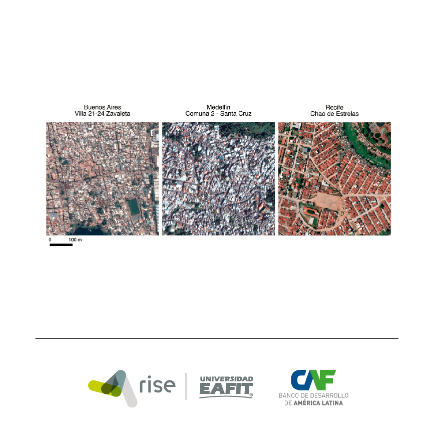
Duque, Juan C; Patino, Jorge E; Betancourt, Alejandro Exploring the potential of machine learning for automatic slum identification from VHR imagery Artículo de revista Remote Sensing, 9(9) (895), pp. 1-23, 2017, ISSN: 2072-4292. Resumen | Enlaces | BibTeX | Etiquetas: Aprendizaje de máquina, imágenes satelitales, pobreza, Sostenibilidad de ciudades @article{duque2017exploring,
title = {Exploring the potential of machine learning for automatic slum identification from VHR imagery},
author = {Duque, Juan C. and Patino, Jorge E. and Betancourt, Alejandro},
url = {https://doi.org/10.3390/rs9090895},
doi = {10.3390/rs9090895},
issn = {2072-4292},
year = {2017},
date = {2017-08-30},
journal = {Remote Sensing},
volume = {9(9)},
number = {895},
pages = {1-23},
abstract = {Slum identification in urban settlements is a crucial step in the process of formulation of pro-poor policies. However, the use of conventional methods for slum detection such as field surveys can be time-consuming and costly. This paper explores the possibility of implementing a low-cost standardized method for slum detection. We use spectral, texture and structural features extracted from very high spatial resolution imagery as input data and evaluate the capability of three machine learning algorithms (Logistic Regression, Support Vector Machine and Random Forest) to classify urban areas as slum or no-slum. Using data from Buenos Aires (Argentina), Medellin (Colombia) and Recife (Brazil), we found that Support Vector Machine with radial basis kernel delivers the best performance (with F2-scores over 0.81). We also found that singularities within cities preclude the use of a unified classification model.},
keywords = {Aprendizaje de máquina, imágenes satelitales, pobreza, Sostenibilidad de ciudades},
pubstate = {published},
tppubtype = {article}
}
Slum identification in urban settlements is a crucial step in the process of formulation of pro-poor policies. However, the use of conventional methods for slum detection such as field surveys can be time-consuming and costly. This paper explores the possibility of implementing a low-cost standardized method for slum detection. We use spectral, texture and structural features extracted from very high spatial resolution imagery as input data and evaluate the capability of three machine learning algorithms (Logistic Regression, Support Vector Machine and Random Forest) to classify urban areas as slum or no-slum. Using data from Buenos Aires (Argentina), Medellin (Colombia) and Recife (Brazil), we found that Support Vector Machine with radial basis kernel delivers the best performance (with F2-scores over 0.81). We also found that singularities within cities preclude the use of a unified classification model. |
Arribas-Bel, Daniel ; Patino, Jorge E; Duque, Juan C Remote sensing-based measurement of Living Environment Deprivation: Improving classical approaches with machine learning Artículo de revista PloS one, 12 (4), pp. 1-25, 2017, ISSN: 1932-6203. Resumen | Enlaces | BibTeX | Etiquetas: Aprendizaje de máquina, pobreza, Sostenibilidad de ciudades @article{arribas2017remote,
title = {Remote sensing-based measurement of Living Environment Deprivation: Improving classical approaches with machine learning},
author = {Arribas-Bel, Daniel and Patino, Jorge E. and Duque, Juan C.},
url = {https://doi.org/10.1371/journal.pone.0176684},
doi = {10.1371/journal.pone.0176684},
issn = { 1932-6203},
year = {2017},
date = {2017-05-02},
journal = {PloS one},
volume = {12},
number = {4},
pages = {1-25},
abstract = {This paper provides evidence on the usefulness of very high spatial resolution (VHR) imagery in gathering socioeconomic information in urban settlements. We use land cover, spectral, structure and texture features extracted from a Google Earth image of Liverpool (UK) to evaluate their potential to predict Living Environment Deprivation at a small statistical area level. We also contribute to the methodological literature on the estimation of socioeconomic indices with remote-sensing data by introducing elements from modern machine learning. In addition to classical approaches such as Ordinary Least Squares (OLS) regression and a spatial lag model, we explore the potential of the Gradient Boost Regressor and Random Forests to improve predictive performance and accuracy. In addition to novel predicting methods, we also introduce tools for model interpretation and evaluation such as feature importance and partial dependence plots, or cross-validation. Our results show that Random Forest proved to be the best model with an R2 of around 0.54, followed by Gradient Boost Regressor with 0.5. Both the spatial lag model and the OLS fall behind with significantly lower performances of 0.43 and 0.3, respectively.},
keywords = {Aprendizaje de máquina, pobreza, Sostenibilidad de ciudades},
pubstate = {published},
tppubtype = {article}
}
This paper provides evidence on the usefulness of very high spatial resolution (VHR) imagery in gathering socioeconomic information in urban settlements. We use land cover, spectral, structure and texture features extracted from a Google Earth image of Liverpool (UK) to evaluate their potential to predict Living Environment Deprivation at a small statistical area level. We also contribute to the methodological literature on the estimation of socioeconomic indices with remote-sensing data by introducing elements from modern machine learning. In addition to classical approaches such as Ordinary Least Squares (OLS) regression and a spatial lag model, we explore the potential of the Gradient Boost Regressor and Random Forests to improve predictive performance and accuracy. In addition to novel predicting methods, we also introduce tools for model interpretation and evaluation such as feature importance and partial dependence plots, or cross-validation. Our results show that Random Forest proved to be the best model with an R2 of around 0.54, followed by Gradient Boost Regressor with 0.5. Both the spatial lag model and the OLS fall behind with significantly lower performances of 0.43 and 0.3, respectively. |
|
|
2021
|
Calderón, E; Duque, Juan C Justicia espacial: Integración socioespacial de población desplazada a la sociedad de acogida Informe técnico RiSE-group (8), 2021. Enlaces | BibTeX | Etiquetas: peak_vision, Sostenibilidad de ciudades @techreport{peak_vision_8s,
title = {Justicia espacial: Integración socioespacial de población desplazada a la sociedad de acogida},
author = {Calderón, E. and Duque, Juan C.},
url = {https://www.rise-group.org/wp-content/uploads/2021/11/PEAK-VISION-JUSTICIA-ESPACIAL.pdf
https://www.rise-group.org/wp-content/uploads/2021/11/PEAK-VISION-SPATIAL-JUSTICE.pdf},
year = {2021},
date = {2021-11-17},
number = {8},
institution = {RiSE-group},
keywords = {peak_vision, Sostenibilidad de ciudades},
pubstate = {published},
tppubtype = {techreport}
}
|
Patiño, Jorge E; Hong, Andy ; Duque, Juan C; Rahimi, Kazem ; Zapata, Silvana ; Lopera, Verónica M ¿Qué es lo que hace que el entorno urbano sea saludable en Colombia? Informe técnico RiSE-group (3), 2021. Resumen | Enlaces | BibTeX | Etiquetas: briefings, ODS 11, Sostenibilidad de ciudades @techreport{peak_briefing_3s,
title = {¿Qué es lo que hace que el entorno urbano sea saludable en Colombia?},
author = {Patiño, Jorge E. and Hong, Andy and Duque, Juan C. and Rahimi, Kazem and Zapata, Silvana and Lopera, Verónica M.},
url = {https://www.rise-group.org/wp-content/uploads/2021/06/briefing_3sp.pdf
https://www.rise-group.org/wp-content/uploads/2021/06/briefing_3eng.pdf},
year = {2021},
date = {2021-06-24},
number = {3},
institution = {RiSE-group},
abstract = {Este informe presenta evidencia de investigaciones recientes sobre las relaciones existentes entre las características del entorno urbano y la mortalidad por enfermedades cardiovasculares y diabetes en Medellín, Colombia. Un mejor conocimiento de esas relaciones en el contexto de
las ciudades de países de ingresos medios y bajos puede incidir en mejores lineamientos de planeación urbana y con ello contribuir a disminuir la carga de las enfermedades no transmisibles en las ciudades de estos países.},
keywords = {briefings, ODS 11, Sostenibilidad de ciudades},
pubstate = {published},
tppubtype = {techreport}
}
Este informe presenta evidencia de investigaciones recientes sobre las relaciones existentes entre las características del entorno urbano y la mortalidad por enfermedades cardiovasculares y diabetes en Medellín, Colombia. Un mejor conocimiento de esas relaciones en el contexto de
las ciudades de países de ingresos medios y bajos puede incidir en mejores lineamientos de planeación urbana y con ello contribuir a disminuir la carga de las enfermedades no transmisibles en las ciudades de estos países. |
Ospina, Juan P; Botero-Fernandez, V; Duque, Juan C; Brussel, Mark ; Grigolon, Anna Movilidad Sostenible: ¿Qué tanta distancia viaja regularmente la gente de Medellín en bicicleta? Informe técnico RiSE-group (6), 2021. Enlaces | BibTeX | Etiquetas: bicicletas, ODS 11, peak_vision, Sostenibilidad de ciudades, Transporte en ciudades del sur global @techreport{peak_vision_6s,
title = {Movilidad Sostenible: ¿Qué tanta distancia viaja regularmente la gente de Medellín en bicicleta?},
author = {Ospina, Juan P. and Botero-Fernandez, V. and Duque, Juan C. and Brussel, Mark and Grigolon, Anna},
url = {https://www.rise-group.org/wp-content/uploads/2021/03/peak_vision_6s.pdf
https://www.rise-group.org/wp-content/uploads/2021/03/peak_vision_6e.pdf},
year = {2021},
date = {2021-02-01},
number = {6},
institution = {RiSE-group},
keywords = {bicicletas, ODS 11, peak_vision, Sostenibilidad de ciudades, Transporte en ciudades del sur global},
pubstate = {published},
tppubtype = {techreport}
}
|
2020
|
Quiñones, Mauricio ; Duque, Juan C; Cuartas, Daniel La relevancia del mejoramiento del esquema de subsidios cruzados por consumo de servicios públicos domiciliarios Informe técnico RiSE-group (2), 2020. Enlaces | BibTeX | Etiquetas: Ciudades y su economía, Reporte técnico, Sostenibilidad de ciudades @techreport{peak_report_2s,
title = {La relevancia del mejoramiento del esquema de subsidios cruzados por consumo de servicios públicos domiciliarios},
author = {Quiñones, Mauricio and Duque, Juan C. and Cuartas, Daniel},
url = {https://www.rise-group.org/wp-content/uploads/2021/01/reporte_2.pdf},
year = {2020},
date = {2020-08-01},
number = {2},
institution = {RiSE-group},
keywords = {Ciudades y su economía, Reporte técnico, Sostenibilidad de ciudades},
pubstate = {published},
tppubtype = {techreport}
}
|
Mejía-Dugand, Santiago ; Pizarro-Castillo, Marcela Aterrizando los Objetivos de Desarrollo Sostenible (ODS) a través de instrumentos de planificación existentes Informe técnico RiSE-group (2), 2020. Resumen | Enlaces | BibTeX | Etiquetas: briefings, Sostenibilidad de ciudades @techreport{peak_briefing_2s,
title = {Aterrizando los Objetivos de Desarrollo Sostenible (ODS) a través de instrumentos de planificación existentes},
author = {Mejía-Dugand, Santiago and Pizarro-Castillo, Marcela},
url = {https://www.rise-group.org/wp-content/uploads/2021/01/briefing_2.pdf
https://www.rise-group.org/wp-content/uploads/2021/03/briefing_2e.pdf},
year = {2020},
date = {2020-08-01},
number = {2},
institution = {RiSE-group},
abstract = {Este informe discute cómo los Objetivos de Desarrollo Sostenible (ODS) pueden alcanzarse en una ciudad al conectarlos con instrumentos de planificación territorial existentes. Cuando esta conexión se realiza de manera efectiva, el progreso hacia el alcance de los ODS puede trascender los planes de desarrollo y las prioridades políticas de las administraciones sin afectar su autonomía.},
keywords = {briefings, Sostenibilidad de ciudades},
pubstate = {published},
tppubtype = {techreport}
}
Este informe discute cómo los Objetivos de Desarrollo Sostenible (ODS) pueden alcanzarse en una ciudad al conectarlos con instrumentos de planificación territorial existentes. Cuando esta conexión se realiza de manera efectiva, el progreso hacia el alcance de los ODS puede trascender los planes de desarrollo y las prioridades políticas de las administraciones sin afectar su autonomía. |

